|
|
Landforms
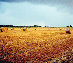 The Mixedwood Plains consists mostly of level plains and gently rolling hills, and contains about 9% of Canada’s land. A carbonate-rich Paleozoic bedrock underlies most of this ecozone, which consists of deep moraine, lacustrine, and marine/estuarine deposits. The Mixedwood plains was buried under more than 1 km of ice until 11 000 years ago when the ice age ended. After the ice age, the Champlain Sea covered the St. Lawrence and lower Ottawa valleys for the following 1 200 years. Glacial action and the Champlain Sea (which is now extinct) created thick moraine clay deposits. Mesozoic and Paleozoic sedimentary rock are contained under agricultural fields and urban centers.
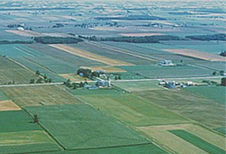 The flat-lying St. Lawrence Lowlands specifically consist of limestone, shale, and sandstone. More than 6 000 drumlins are scattered throughout the ecozone’s southern stretches between lakes Huron, Ontario, and Erie. In fact, the four great lakes in the Mixedwood plains – Lakes Superior, Huron, Erie, and Ontario – contain about 20% of the world’s freshwater on their own.
A Joshua Liu and Timothy Yip Production 2003-2004
|
|